
Winter storm slams the West Coast, prompting rare blizzard warnings in Southern California
A slow-moving winter storm has struck the West Coast, flooding highways in Los Angeles and prompting rare blizzard warnings in Southern California.
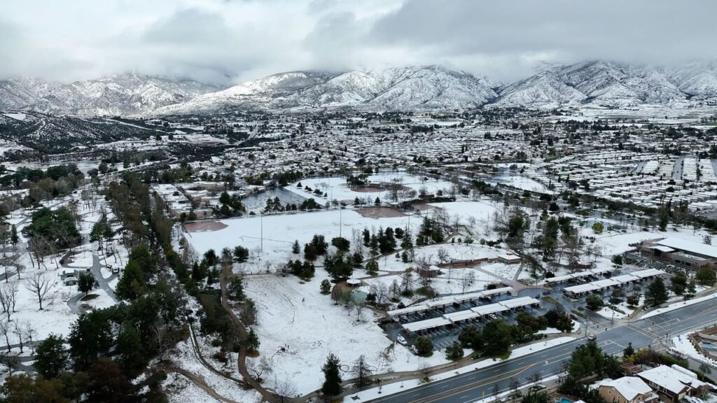
In its first-ever blizzard warning, the National Weather Service in San Diego said the San Bernardino County mountains could see 3 to 5 feet of snow through Saturday morning.
Blizzard warnings were also issued for Los Angeles and Ventura counties through Saturday afternoon. Up to 5 feet of snow is possible with some isolated areas seeing between 7 and 8 feet. The National Weather Service’s Los Angeles office issued its last blizzard warning on February 4, 1989.

Heavy rain fell Friday afternoon in Los Angeles and flooding shut down numerous thoroughfares the area. The NWS issued a flash flood warning for the city – the second highest level of flood warning from the NWS, only topped by a flood emergency.
Up to 5 inches of rain could fall across lower elevations of the greater Los Angeles area while the mountains could see 6 inches. In the San Diego area, up to 3 inches of rain is possible in lower elevations while the mountains could get 7 inches.
Over 6 million people are covered by the flood warning, including downtown Los Angeles, Pasadena, Beverly Hills, Burbank and Santa Barbara.

“This storm system will be unusually cold, and snow levels will be very low. In fact, areas very close to the Pacific Coast and also into the interior valleys that are not accustomed to seeing snow, may see some accumulating snowfall,” the National Weather Service said early Friday.
“The worst impacts from flooding and blizzard conditions occur Friday afternoon through Saturday morning, when any non-essential or non-emergency travel should be postponed!” the San Diego weather service said.
Wind gusts may hit 75mph
The storm has put more than 20 million people under flood watches and more than 30 million people under high wind alerts across Southern California – roughly two months after the state endured rounds of deadly flooding. The highest gusts in the warning areas could reach 75 mph.
Up to 6 inches of snow is possible across lower elevations and up to 3 feet could fall on the region’s highest peaks before conditions begin to improve by Friday evening as the storm slips to the south.
“Heavy snow, winds gusting as high as 60 mph, will cause zero visibility due to blowing and drifting snow,” the weather service warned.
Snow has already hit the Santa Cruz Mountain, resident Ngugi Kihara told CNN on Friday.
“We never seen this much snow up here,” Kihara said. “We woke up to it. It started yesterday but picked up a lot overnight. Lots of trees are falling and all the roads around us are closed. Power is out and has been mostly gone since Tuesday.”
Power outages were already adding up in California late Friday, with nearly 99,000 customers in the dark, largely in the northern region, according to poweroutage.us.
Power outages continue in the Midwest
As the storm struck the West, a ferocious, multiday winter storm began to subside after wreaking havoc in several states across the West, northern Great Plains, the Great Lakes region and New England.
Over 640,000 utility customers in Michigan are without power in the state, according to poweroutage.us and DTE, one of Michigan’s largest electric providers, said it won’t get most of its customers back online before Sunday.
Twenty percent of DTE’s customers were without power as of Friday afternoon, DTE CEO Jerry Norcia said in a press conference. This is more than 480,000 customers according to poweroutage.us.
By the end of the day on Friday, the company expects to restore power to 200,000 customers. By Sunday the utility hopes to bring nearly all customers back to service, Norcia said.
Wayne County is currently the hardest hit area with over 227,000 customers offline due to this week’s winter storm. Nearby Oakland County has another 112,000 without power.
The forecast low temperature in the Detroit area Friday night is 23 degrees, according to the NWS.
Brutal storm triggers rescue efforts
Several counties in Wyoming went into search-and-rescue mode after more than 40 inches of snow fell in the southern parts of the state over the course of several days and motorists were trapped in heavy snow, the state highway patrol said on Twitter.
Minneapolis, Minnesota, saw more than 13 inches in a three-day period this week. More than 160 vehicle crashes were reported statewide, and dozens of cars spun off roads Wednesday, a spokesperson for the Minnesota State Patrol said in a series of tweets.
Minneapolis officials have declared a one-day snow emergency beginning Friday, and city crews have been plowing and treating streets.
Since the storm began Monday evening, cumulative snowfall reached dozens of inches in some cities, including 48 inches in Battle Lake, Wyoming, 32 inches in Dupuyer, Montana, and 29 inches in Park City, Utah.
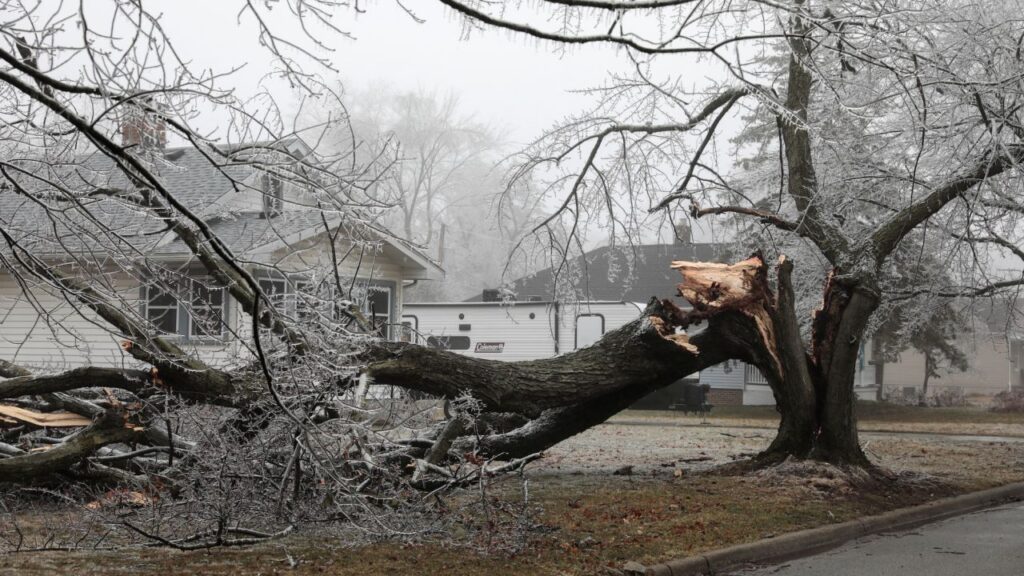
But snow was not the storm’s only culprit. Severe icing was also a danger.
Ann Arbor, Michigan, recorded 0.65 inches, while Fransville, Wisconsin, measured 0.75 inches of ice.
And in New England, icy conditions likely contributed to a massive 15-vehicle pileup on the Massachusetts Turnpike Thursday night, according to a tweet by the Massachusetts State Police.
The chain-reaction crash involved multiple personal vehicles and tractor trailers, officials said. Troopers, firefighters and EMS responded to the incident and multiple victims had to be transported to the hospital, according to the tweet.
Southern US sees record heat
As northern regions of the country were measuring snowfall and ice accumulation, parts of the Southeast were experiencing record-high heat.
More than 50 daily record highs were recorded in the Southeast Thursday.
- St. Simons Island, Georgia, saw a high temperature of 88 degrees, an all-time February record.
- Tupelo, Mississippi, reached a high temperature of 87 degrees, another an all-time February record. The previous record of 84 degrees was set Wednesday.
- Raleigh, North Carolina, saw a high temperature of 85 degrees, which was an all-time February record. The previous record of 84 degrees was set in 1977. source