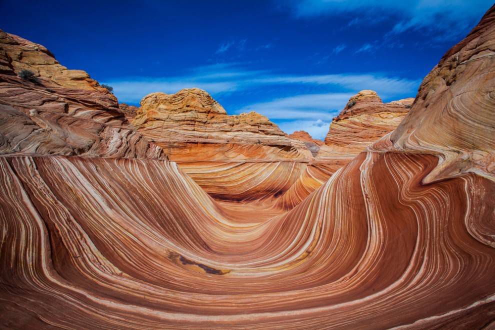
Coyote Buttes and The Wave – visit famous “Wave” crossbedded sandstone site in Arizona
Navajo Sandstone, Arizona – United States
The Navajo sandstone is estimated to cover 400,000 km2 of the western United States and is found spread across the states of Nevada, Arizona, Colorado and Utah as part of the Colorado Plateau. The formation consists of thick layers of highly-angled cross-bedded sandstones, just like those found at Alderley edge. The rocks are predominantly composed of rounded quartz grains and were formed in a vast ancient desert of sand dunes, or erg, similar to the modern Sahara Desert.
The Navajo Sandstone is one of the most extensive and most exposed aeolian (wind-blown) systems known in the geologic record. This enormous sand sea was deposited in the Early Jurassic, approximately 190 million years ago, as a result of regional tectonics and mountain building in what is now the western United States.
During the Early Jurassic the Colorado Plateau region was part of a large sedimentary basin located between 10-20° north of the equator in an extremely arid climate. This basin is thought to have formed due to the downward flexing of the lithosphere in response to an accumulation of mass in the developing North American Cordillera occurring on the western flank of the American plate. High rates of continued subsidence in the basin created more space and allowed more sediment to be deposited resulting in the accumulation of thick sedimentary successions. This subsidence also would have resulted in decrease in air pressure over the region which caused regional winds to decelerate, and deposit the fine sand particles they were carrying forming the huge desert of dunes.
 |
|
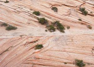
| Cross bedding in the Navajo Sandstone: © Zion National Park |
The dramatic cross-bedding structures found in the Navajo Sandstone provide a record of lee-ward deposition on the sand dunes and therefore display the history of ancient wind patterns and dune migration in the Early Jurassic Colorado Plateau. The orientation of these cross-bedding structures indicates that the dominant wind pattern during this time would have been from the north-northwest. However, radioisotopic dating of detrital zircon grains found in the Navajo Sandstones indicates that at least some of the sediment came from as far away as the ancient Appalachian Mountains of eastern North America. It is therefore thought that sediment would have been transported from the Appalachians westwards across most of North America by a huge continental-scale ancient river system, somewhat like the modern Mississippi river system, and then later blown by desert winds to the Colorado Plateau region.
South-westerly winds continue to sculpt and scour the geomorphology of the Navajo Sandstone today creating small-scale erosional bedforms as well as spectacular large-scale, U-shaped troughs such as ‘The Wave’ in Arizona. source
The Wave is a truly remarkable geological formation famous in outdoor and photography communities. Given the access restrictions to the area, the hype about this formation is immense; it is also completely justified. The Wave is a unique Navajo Sandstone rock formation dating to the Jurassic period. Early erosion occurred due to infrequent runoff, but it is now is almost exclusively wind driven. The result of this erosion is the exposure of spectacular eolian cross bedding in the sandstone, present as innumerable ridges and ripples.
The Wave is located in North Coyote Buttes, which is a visitor use limited section of the Paria Canyon-Vermillion Cliffs Wilderness on the Arizona and Utah state line. Only 20 persons are allowed to enter the North Coyote Buttes area per day. Permits are awarded via two lottery systems, and 10 individuals are awarded permits from each: (1) an online lottery held four months in advance or (2) an in-person lottery held one day prior to the permit date. Current and detailed information on the lottery system can be found here.
The trek to the wave begins from Wire Pass Trailhead, but it follows no established trail. Rather, the route traverses mostly slickrock and sand terrain. The BLM does not place permanent signs or cairns in the wilderness, but it does provide a pamphlet with useful images and GPS coordinates. Still, good backcountry navigation skills are necessary. Even in “cooler” months heat can be oppressive given that the terrain is largely exposed to the elements. Between the extreme environmental conditions and the lack of any permanent water sources in the vicinity, it is recommended that you begin your adventure early in day.
Numerous additional adventures are available in this area if a permit can not be obtained, including adventures in South Coyote Buttes, Wire Pass, and Buckskin Gulch. At times, travel on House Rock Valley Road will require high clearance and/or four-wheel drive. Check with BLM stations in the area to determine the latest road condition information. source
Cross-bedded Sandstone
Large-scale cross-bedding is common throughout Zion National Park. The cross-bedding is typical of ancient sand-dune deposits of the Navajo Sandstone. During Early Jurassic time (about 202 to 176 million years ago), the region was part of a great sandy desert, probably similar in size and scale to the ergs (dune fields) of the modern Sahara Desert or Arabian Peninsula (Blakey, 1994).
https://youtu.be/y8UsjSWXWLU?si=zs-ewxguWPt6GlOT
Coyote Buttes North Advanced Lottery (The Wave)
Important Dates
| DATES | INFORMATION |
|---|---|
| March 12, 2023 – November 4, 2023 | Daylight Savings Time. During this period, Utah is 1 hour ahead of Arizona (Except the Navajo Nation which does follow Daylight Savings). This system follows the current time Utah operates in. |
| November 5, 2023 – March 10, 2024 | Daylight Standard Time. During this period, Utah and Arizona are the same time. |
| November 23, 2023 | Permit pick-up locations closed – an email will be sent to lottery winners with details concerning permit pick-up. |
| December 25, 2023 | Permit pick-up locations closed – an email will be sent to lottery winners with details concerning permit pick-up. |
| January 1, 2024 | Permit pick-up locations closed – an email will be sent to lottery winners with details concerning permit pick-up. |
Lottery Information
Applications can only be submitted from within the designated geofence, according to the following schedule.
refer to the Getting Here section regarding potential differences in time between Utah & Arizona.
Lottery Schedule:
Day 1 – Application: Apply between 6 AM and 6 PM two days ahead of the desired entry date. Lottery results are sent out at 7:15 PM this evening. Window opens to accept winning lottery.
Day 2 – Safety Briefing: Successful applicants must accept the permit and pay fees by 8 AM Utah time and be onsite at a permit pickup location at 8:30 AM local time for a safety briefing. Local time may be different between pick-up locations. During Daylight Savings, 9:30 in Utah is 8:30 in Arizona (except the Navajo Nation). *Arriving late will void permits.
Day 3 – Permit date: Permit-holders have the day to explore Coyote Buttes North.
Applications can only be submitted via a mobile device (ex. smart phone, internet-connected tablet) on the Recreation.gov mobile app or a browser.
How Does the Quota Work for this Permit?
The quota for this permit is measured in persons and/or groups visiting the area per day. A daily maximum of 64 people are permitted to visit Coyote Buttes North.
- 16 people and/or 4 groups (whichever comes first) are awarded through this Daily Lottery.
- 48 people and/or 12 groups (whichever comes first) are awarded through the Advanced Lottery, a separate process than this geofence Daily Lottery.
- The maximum group size for both lotteries is 6 people.
- Everyone, regardless of age, must be included in the permit. This includes infants that are not walking.
- Dogs do not count against the quota, but must be included on the permit and require a fee. Dogs are added during the permit confirmation process following a successful lottery application.
- If a group obtains a permit and hires an authorized guide, the guide will not count against the group size or the daily visitor limit. Groups are limited to one guide each.
Important Dates
| DATES | INFORMATION |
|---|---|
| January 1, 2023 – January 31, 2023 | Lottery open to applications for permits during May |
| February 1, 2023 | Lottery runs at 9am MT for permits during May |
| February 1, 2023 – February 28, 2023 | Lottery open to applications for permits during June |
| March 1, 2023 | Lottery runs at 9am MT for permits during June |
| March 1, 2023 – March 31, 2023 | Lottery open to applications for permits during July |
| April 1, 2023 | Lottery runs at 9am MT for permits during July |
| April 1, 2023 – April 30, 2023 | Lottery open to applications for permits during August |
| May 1, 2023 | Lottery runs at 9am MT for permits during August |
| May 1, 2023 – May 31, 2023 | Lottery open to applications for permits during September |
| June 1, 2023 | Lottery runs at 9am MT for permits during September |
| June 1, 2023 – June 30, 2023 | Lottery open to applications for permits during October |
| July 1, 2023 | Lottery runs at 9am MT for permits during October |
| July 1, 2023 – July 31, 2023 | Lottery open to applications for permits during November |
| August 1, 2023 | Lottery runs at 9am MT for permits during November |
| August 1, 2023 – August 31, 2023 | Lottery open to applications for permits during December |
| September 1, 2023 | Lottery runs at 9am MT for permits during December |
| September 1, 2023 – September 30, 2023 | Lottery open to applications for permits during January |
| October 1, 2023 | Lottery runs at 9am MT for permits during January |
| October 1, 2023 – October 31, 2023 | Lottery open to applications for permits during February |
| November 1, 2023 | Lottery runs at 9am MT for permits during February |
| November 1, 2023 – November 30, 2023 | Lottery open to applications for permits during March |
| December 1, 2023 | Lottery runs at 9am MT for permits during March |
| December 1, 2023 – December 31, 2023 | Lottery open to applications for permits during April |
| January 1, 2024 | Lottery runs at 9am MT for permits during April |
Lottery Information
You may enter the lottery at any time during a calendar month for a permit during the fourth month ahead. You apply for up to three trip dates per application and will be authorized one if you are successful. Each individual may submit only one application per lottery. Applicants must apply using their legal name and may be required to show a government issued identification card that matches the lottery application. There is no age limit to apply, but there must be adult accompaniment for the hike. Multiple applications to the lottery by the same individual will be cancelled without refund. Individuals cannot concurrently hold more than one permit per permit area. The lottery runs on the first day of the next month at 9 am MDT and applicants are notified of their outcome via email. The permit will be mailed out 4 to 6 weeks following the lottery by Vermilion Cliffs National Monument. Selling or transferring permits is prohibited, will invalidate the permit, and may result in citation.
How Does the Quota Work for this Permit?
The quota for this permit is measured in persons and/or groups visiting the area per day. A daily maximum of 64 people are permitted to visit Coyote Buttes North.
• 48 people and/or 12 groups (whichever comes first) are awarded through the online lottery system.
• The other 16 people and/or 4 groups (whichever comes first) are awarded through the Daily Lottery, a separate process than this online lottery.
• The maximum group size is 6 people. All group members must stay together for the entire hike.
• Everyone, regardless of age, must be included in the permit. This includes infants that are not walking.
• Dogs do not count against the quota, but must be included on the permit and also require a fee. This process occurs during the confirmation of a successful lottery application.
Coyote Buttes North Daily Lottery (The Wave)
Permit & Season Information
A permit is required to visit the Coyote Buttes North permit area, which features “The Wave”. Permits are distributed by lottery, either through this Daily Lottery, two days ahead of the permit date, or through the Advanced Lottery four months ahead of the permit date.
Application submissions to the Daily Lottery are limited by a geofence. To apply, a group member must be within the geofence during the application window of 6:00 AM to 6:00 PM, two days before the permit date.
The lottery is held daily.
Coyote Buttes and The Wave
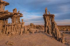
The Wave is the premier photographic destination in the US Southwest. It is located in the Coyote Buttes North area of the Utah Arizona border. In addition to The Wave Coyote Buttes North contains many other spectacular rock formations. These include The Second Wave, The Alcove, Top Rock Arch, Melody Arch and the Grotto, Sand Cove, and Fatali’s Boneyard. The Wave is best photographed from mid-morning to early afternoon so as to minimize the extensive shadows; the other areas listed above are best photographed mid-late afternoon.
A permit issued by the US Bureau of Land Management (BLM) is required to see The Wave. Only 64 people per day (48 permits granted three months in advance and 16 permits granted one day in advance) are allowed in the area and demand far exceeds supply. During the most popular months (April, May, September, October) there can be an estimated 300 people applying for the sixteen daily permits. In the other months you usually have much less than a 50% chance of getting one at the daily lottery. Your chances are better if you’re going alone, or in December – February.
A six mile round trip hike in required to get to The Wave. Since there is no trail to The Wave you should be able to use a map and compass or GPS to help with navigation. The BLM provides a map with your permit and instructions on getting to The Wave, and there are a small number of cairns on the way. Over the past five years five people have died on the way to/from The Wave. If you are not sure about your navigation skills I strongly suggest you hike in with a guide or a friend with these skills. Do not go alone. If you use a GPS be sure to mark the Wirepass trailhead and other key points along the route. Stay with your party. Four of the five fatalities were heat related, so if you go in the warmer months bring plenty of water, at least four liters, and preferably more.
Permits
In order to visit The Wave you need a permit for an area called Coyote Buttes North. Online permits and permit information can be obtained from recreation.gov. At most 64 people, 16 groups are allowed into Coyote Buttes North, whichever comes first. Permits for a total of 48 people, 12 groups maximum are issued via an online lottery held three months in advance. Permits for another 16 people, 4 groups maximum are awarded via an online lottery held two days in advance.
Advanced Permits
Advanced permits for Coyote Buttes North are very difficult to obtain. Demand greatly exceeds supply. All Advanced Coyote Buttes North permits are awarded by lottery held on recreation.gov. The lottery opens up four months in advance of your trip date. You have the whole month to apply. For example, for a January 15 permit you would open the Advanced lottery page in September. The fee to enter the on-line lottery is $9 per group.
Wave permits are non-transferable except for up to three specific people you list when you apply for the lottery. These people are called “alternate permit holders”. If you win a permit and are stopped by a ranger on your hike to The Wave either you or a listed alternate permit holder must be present with your group. If not your group may be ticketed. Alternate permit holders must have an account on recreation.gov.
You may only apply once per month to the lottery. If you try to apply more than once at checkout you will get the message “You have excellent taste! However, you are only allowed to submit or be listed as an alternate permit holder on 1 lottery application or hold 1 active permit(s) reservation at a time.” Note that if you list someone as an alternate permit holder they cannot apply for a permit that month as well. If there are several people in your group each can apply to the lottery separately provided you do not list the other members of the group as alternate permit holders.
On each lottery application you can select up to three dates. The drawing is held the day following the close of the lottery (i.e. October 1 in our example). Shortly after the lottery closes you will be notified via e-mail whether you were successful or not. If you do not receive a notification by the 2nd of the month check your spam folder. If you still haven’t received notification it is likely you typed your email address incorrectly on the application. In this case you should call the BLM at (435) 688-3200 or email them at blm_az_asdoweb@blm.gov for a status. If you win the lottery you will have to pay an additional $7 per person fee for the North Coyote Buttes permit.
Coyote Buttes North Lottery Schedule
|
Apply between
|
for a permit during
|
|
January 1 – 31
|
May
|
|
February 1 – 28
|
June
|
|
March 1 – 31
|
July
|
|
April 1- 30
|
August |
|
May 1 – 31
|
September
|
|
June 1 – 30
|
October
|
|
July 1 – 31
|
November
|
|
August 1 – 31
|
December
|
|
September 1 – 30
|
January
|
|
October 1 – 31
|
February
|
|
November 1 – 30
|
March
|
|
December 1 – 31
|
April
|
Daily permits
If you are unsuccessful in getting an “Advanced permit” for Coyote Buttes North, and are in the Southern Utah / Northern Arizona area, consider getting a “Daily Permit”. Daily permits are issued one day in advance of the day you wish to hike in to The Wave. Starting on March 15, 2022 you can apply for the daily lottery at https://www.recreation.gov/permits/4251909 two days in advance of your desired entry date. There is a $9 fee to try for a permit. You can only apply via your phone or connected mobile device (e.g. tablet). You cannot apply via a dekstop computer. The GPS on your phone must be on. You must be within a “geofenced” area in Northern Arizona/Southern Utah to apply. The area includes the towns of Kanab, Page, Big Water, Fredonia, Glendale, and Jacob Lake among others. You can download a full resolution map of the geofenced area in a variety of geocoded formats below:
| GeoTiff – Avenza | KMZ – Google Earth | Rmap – Oruxmaps | SQLite – Locus | MBTiles – GaiaGPS | GeoPDF |
You can load this map onto your phone’s GPS software to see whether you are in the geofenced area.
The procedure to apply for a daily permit is as follows:
- Applications for the Daily Lottery must be submitted from within the designated geofence, according to the following schedule.
- Day 1 – Application: Apply between 6 AM and 6 PM two days ahead of the desired entry date on recreation.gov. Lottery results are sent out at 7:15 PM that evening. A window will open to accept winning lottery applications.
- Day 2 – Safety Briefing: Successful applicants must accept the permit and pay fees by 8 AM Utah time and be onsite at a permit pickup location at 8:30 AM local time for a safety briefing. Local time may be different between pickup locations. During Daylight Savings, 9:30 in Utah is 8:30 in Arizona (except the Navajo Nation). There are two permit pickup locations, one in Page and one in Kanab. To pick up your permit in Kanab go to The Kanab Center, 20 N 100 E, Kanab, UT 84741. To pickup your permit in Page, go to Page-Lake Powell HUB, 48 S Lake Powell Blvd, Page, AZ 86040.
- Day 3 – Permit date: Permit-holders have the day to explore Coyote Buttes North.
The new “Daily Permit” system is more user-friendly than the old walk-in lottery. You no longer need to be present in Kanab at 9:00 AM the day before you wish to hike to The Wave. You only need to be in the general area of Page and Kanab. You can go out for an early morning photoshoot or sleep-in if you wish. There is one downside, the $9 per group fee to enter the lottery. the walk-in lottery was free.
Additional information about permits can be found on Coyote Buttes permits webpage.
When to Go / Climate
December – February
It is “relatively” easy to get permits in December, January and early February, especially through the walk-in process. Permits are hard to get around the Christmas and Ne Years holidays so avoid these times. There is a good chance there will be snow on the ground in the winter months. Snow makes hiking difficult and photographing the patterns in the red rock chancy. If there is snow you may be limited to shooting southern exposures such as The Boneyard and Sand Cove. Average cloud cover is also high in the winter months, and House Rock Road is often muddy and difficult or impossible to drive on. The South Buttes are even higher in elevation than the Wave, about 6,200 feet, or four degrees cooler. This makes snow even more likely in the South Buttes, and it will last longer. I have been to Cottonwood Cove when the north facing exposures had over a foot of snow on them.
March – May
These are good months to visit, especially April and May when cloud cover is low and temperatures moderate. Getting a permits is very difficult. Average wind speed is highest in the southwest in the Spring. The wind comes from the Southwest in this area all year round peaking in the afternoon. Sand Cove runs North – South and forms a natural wind tunnel. This makes good photography of Sand Cove and The Boneyard difficult in the Spring. Average cloud cover is low during May.
June
A very good month to go to The Wave if you don’t mind the heat. Cloud cover is low as is precipitation. The best month for night photography as the Milky Way stretches across the sky.
July – August
I used to believe these were the worst months to go to The Wave. I now believe they are reasonably good, if you are prepared and can stand the heat. Average daily high temperature at the Wave is 101 ºF in July and there is little shade. If you go in July do not plan to be out all day. Either go in the morning when temperatures and cloud cover are lower, or go in mid afternoon if the weather looks cooperative. In 2013 there were three heat related fatalities at the Wave, and there was another heat related death in 2018. Go prepared. If you plan to stay the whole day you will need to find shade. A space blanket can help, you need to elevate it with hiking sticks, rocks, bushes, … A good place to find natural shade is on Toprock at the Alcove. Finally bring at least one gallon of water per person in July and August. You will need it. I have seen recommendations of nine liters per person per day when temperatures are this high! Keep water inside your pack so it stays cooler, and bring some of it in the for of ice. There is a good possibility of afternoon thunderstorms or even hail. Mornings are cooler, often clear, and have little wind. It’s likely you can get a good photograph in the morning, and if the weather cooperates you may get a great one in the afternoon! With luck there will be water at the Wave or in the water pockets south of The Wave. Water pockets won’t last long given the average July August temperatures though. If there are water pockets look for tadpoles and tadpole shrimp. If there’s a lot of water you may even hear toads croaking! (males calling for females). Permits, though still difficult, are easier to get than during the peak months.
September – November
Excellent months for visiting, Page and Kanab are less crowded than during summer vacation, and cloud cover and temperatures are reasonable. Permits are very difficult to get. The rest of the Southwest is also beautiful at this time of year with the Aspens changing in late September/early October, and the Cottonwoods in late October.
Another good source of climate information based on the Page airport data can be found at Weatherspark.com.
Getting to The Wave
There are two entry points to Coyote Buttes North, Wirepass Trailhead (WP) and The Notch. The Notch is no longer actively publicized by the BLM. The trail from the Notch is poorly defined. I strongly recommend access from the Wirepass parking lot. To get to the Wirepass trailhead take Highway 89 to House Rock Road. The House Rock Road turnoff is between mile posts 25 and 26 on Highway 89 in Utah. House Rock Road is normally passable by passenger cars. Do not take this road if it is wet. It is clay based and impassable even to 4WD vehicles when wet. When the road is muddy it is like driving on ice and there are drop-offs. When dry take House Rock Road for 8.4 miles to the WP parking area on the right. You can dry camp at the Wirepass trailhead, and a toilet is present. Better camping with fire pits, tables, and pit toilets is available at the Stateline Campground, one mile further south just off House Rock Road.
Begin your hike to the Wave by signing the trailhead register and crossing House Rock Road. Follow the well defined trail east for fifty yards until you enter the wash. Wirepass wash feeds into Buckskin Gulch, the longest slot canyon in North America. Continue walking down the wash. About .55 miles from the trailhead you will see a sign marked Coyote Buttes on the right. Turn right and follow the good trail up the hill and across the sage field. At the end of the field you will cross a wash. This wash also flows into the Wirepass slot canyon one half mile downstream. Total distance across the sage field to the wash is about .65 miles. After crossing the wash hike up the slickrock to a sometimes cairned saddle. If you have a GPS mark this location. You are now in the permit area. From here there may or may not be cairns and they may or may not be accurate. There are a small number of BLM sign posts in the area at critical locations, one can be seen about 50 yards east of the saddle. Note its location, on your return this marker will tell you where to turn to the west. From the saddle proceed south, after .35 miles or so you will see a twin butte with a downed barbed wire fence on its left (east) side, either go over the fence (easy but a little exposed) or walk around the buttes via their the west side. Continue heading almost due south aiming for the crack in the cliffs to the south. After another .8 miles or so you will cross another small wash, continue heading towards the crack in the Wall and go up the sand dune. There should be a clear trail up the sand dune unless it had been very windy overnight. You will shortly arrive at The Wave. It is about 2.8 miles in total from the WP trailhead to The Wave.
Returning to the trailhead
It is fairly easy to get back to your car, even at dusk. The small sign posts installed by the BLM will glow in the dark if a flashlight is shined on them. Make sure that when you return you do not try to cross the ridge too early after heading north. Look for the sign post referenced above, it will tell you when to turn to cross the ridge. It should be easy to cross over the small ridge; if not you have turned west too early. Conversely if you go too far north you will end up in or overlooking Wirepass slot canyon. If so turn around and try again. For an interesting story of someone who got lost on the return, see Trouble in Coyote Buttes. If you get lost or injured and need help try to gain elevation. You may be able to get a cell signal. I have gotten service via Verizon, and a friend via AT&T.
Your day at The Wave
Start at The Wave
So you’ve finally gotten a permit and want to make the best use of it. There is a nice loop hike starting and ending at The Wave. It covers most of the best photo sites in Coyote Buttes North and, if you are willing to be out most of the day, you can hit all of them in good light. Being out all day is dangerous in the summer months, so only do the loop from September through May. The loop does not include Top Rock, unless you are a very strong hiker save this for a second trip.
The first stop on the loop hike is The Wave. The Wave gets good light about an hour after sunrise, before then parts of it are in shadow. It takes about 90 minutes to hike from the Wirepass trailhead to The Wave. Most people start their hike very early in the day and end up leaving when they run out of energy, usually before best light. If you have the stamina to stay out 10-15 hours begin hiking at dawn; otherwise I suggest you start your hike later. Do not start hiking too late as shadows start to hit the south wall of The Wave before mid-day. After shooting The Wave explore the area around it for an hour or two. There are usually some nice water pools 150 yards southeast of The Wave. Ginger Rock is a good subject mid-day. It can be found about 200 yards north of The Wave.
Best early morning
Best shot at mid-morning
Best late morning
Best in the afternoon
Dinosaur Tracks and The Boneyard
Leave The Wave by retracing your steps back down the sand dune to the wash below. At the foot of the dune turn west, cross the wash, and ascend to the area with the dinosaur tracks. The tracks are located in red stone very close to the wall. If you are not experienced in finding tracks they can be hard to locate even with GPS coordinates. The tracks are three toed and hand sized. They usually come in a small cluster arranged in a line. I left a small circle of rocks around a pair of footprints about ten years ago, as of mid 2017 the circle was still there.
After visiting the dinosaur tracks continue south about .3 miles till you reach an open area. Fifty yards or so to the west lies a small brown and yellow striped area with some rocks that look like a tic-tac-toe board lying on the stripes. The area was named “The Boneyard” by photographer Michael Fatali. The loose rocks are called lace or box rocks. Please do not move them, they are fragile. Wait until the cliffs to the northwest of The Boneyard are in shadow before shooting; the dark background of the cliffs contrasts with The Boneyard nicely. Stay until the sun goes behind the cliffs to the west and The Boneyard starts to fall into shadow. If you are feeling energetic you can Note that The Boneyard is also very good at dawn, light hits it just after sunrise with March and September being optimal times to shoot it at dawn.
Lace rock north of The Boneyard
Sand Cove
After leaving The Boneyard head down the sandy wash which runs south-east. In .2 miles turn more to the south into Sand Cove Wash. Continue up Sand Cove Wash about 100 yards and hike up to the teepees to your east (left). This area contains beautiful sandstone curves and is called Sand Cove. It is best captured late afternoon just before it goes into shadow. A wide-angle lens is needed. Sand Cove is largely in shadow in the morning. Stay at Sand Cove until it starts going into shadow.
The Second Wave
From Sand Cove hike east north-east and scramble up the cliff until you reach a flat area just before a much steeper cliff. The Second Wave is at the foot of this steep cliff. It is a great late afternoon location, but only fair the rest of the day. Shoot it from the small sand dune a few yards south, or from the rocks to the south east about ten feet above it. Make sure the cliffs to the west are in shadow. Shoot until the Second Wave goes into shadow. Leave a bit earlier if you are concerned about hiking back to your car after sunset.
To return to the Wirepass parking lot head north passing back through The Wave. There should be many good photo-ops along the hike back so don’t put your camera / tripod away too soon. After leaving The Wave head down the sand dune, cross the wash, and head north to retrace your steps back to your car. “The Dive” and the North and South “Teepees” will be in good light on the way back. You will need a long lens to shoot them. If you hurry you should be able to get back to your car 30-45 minutes after sunset. Warning – if you do not have good navigation skills or have a GPS and know how to use it, you should leave The Second Wave well before sunset.