Deadly Christmas week bomb cyclone:
unleashes damaging winds and brutally cold temperatures across country
The combination of dangerous driving conditions and frigid temperatures has been blamed for at least 9 deaths across 5 states.
Source FOX Weather
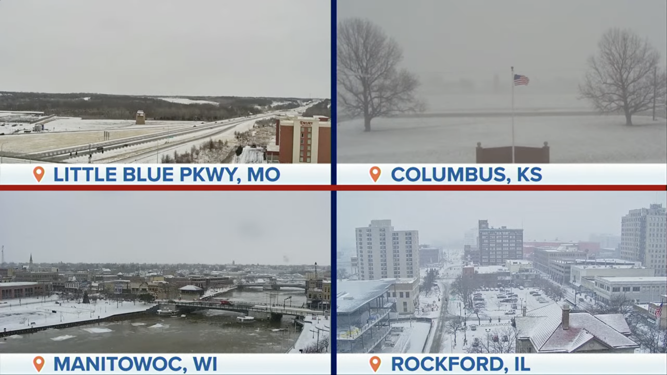
 A dangerous blizzard intensified into a bomb cyclone Friday as it walloped the Great Lakes and Northeast with snow, damaging winds and plummeting temperatures, creating a travel nightmare for millions trying to reach their destination before the Christmas holiday.
The storm’s central pressure dropped by 30 millibars in the 24 hours, officially surpassing the criteria for bombogenesis, which is a 24-millibar drop in 24 hours.The combination of dangerous driving conditions and frigid temperatures has been blamed for at least 13 deaths in half a dozen states.
Three people were killed in weather-related crashes in Oklahoma, along with another three people on the slick roads in Kentucky and one person whose vehicle overturned in Missouri. One person also died in Texas after prolonged exposure to subfreezing temperatures.
At least one person was killed and several injured during a massive 50-vehilce pileup on the Ohio Turnpike, near Sandusky, Ohio. The Ohio State Highway Patrol warned of near-white out conditions and cautioned travelers to stay home. The state’s governor said he was aware of a total of four weather-related deaths across the state, as a result of weather-related crashes.
 Earlier this week, deputies in the Portland, Oregon, area reported roadways were icy when a semi-truck crashed into the scene of a previous wreck on Tuesday along Interstate 84, where one man was killed.
Wind gusts that were tropical storm force and even hurricane force in some areas knocked power out to more than 1.4 million customers from Texas to Maine, with a separate ice storm causing outages in the Pacific Northwest.
In anticipation of the substantial impacts, several states issued states of emergencies to enable resources for the response to the winter storm system.
The winds knocked down trees and limbs, which damaged electrical equipment, and inflatable Christmas decoctions were no match for Mother Nature.
The wind helped usher in bitterly cold, life-threatening air with freezing temperatures expected to reach all the way to South Florida. The cold snap could be the Sunshine State’s coldest Christmas in more than 30 years.
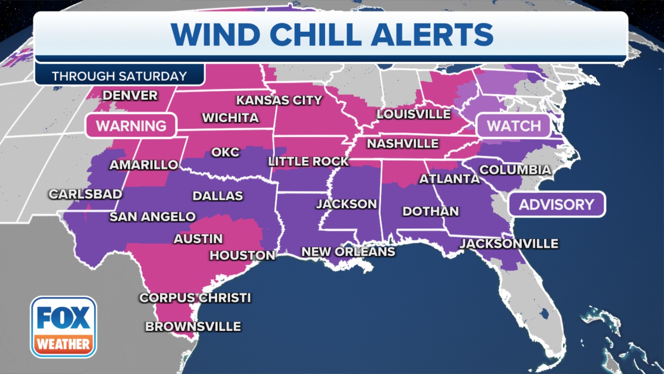
The combination of the wind and bitterly cold temperatures caused wind chill values to reach dangerous levels across much of the eastern half of the nation.
Many of the ingredients were in place for a travel nightmare with more than 150 million Americans under some type of winter weather alert.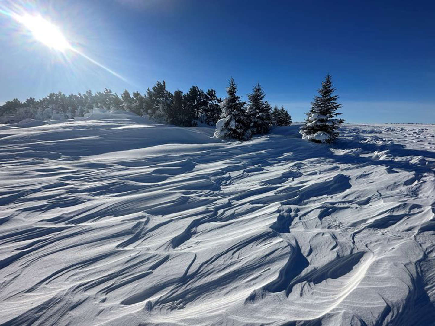
U.S. deep freeze forecast to break Christmas Eve records
Deadly Christmas Bomb Cyclone Record-breaking cold, life-Threatening wind chills plunge America Into Deep Freeze
Data from FlightAware showed more than 8,000 flights had been canceled across the U.S. through Saturday, and more than 20,000 flights that were delayed in a 3-day period since Wednesday.
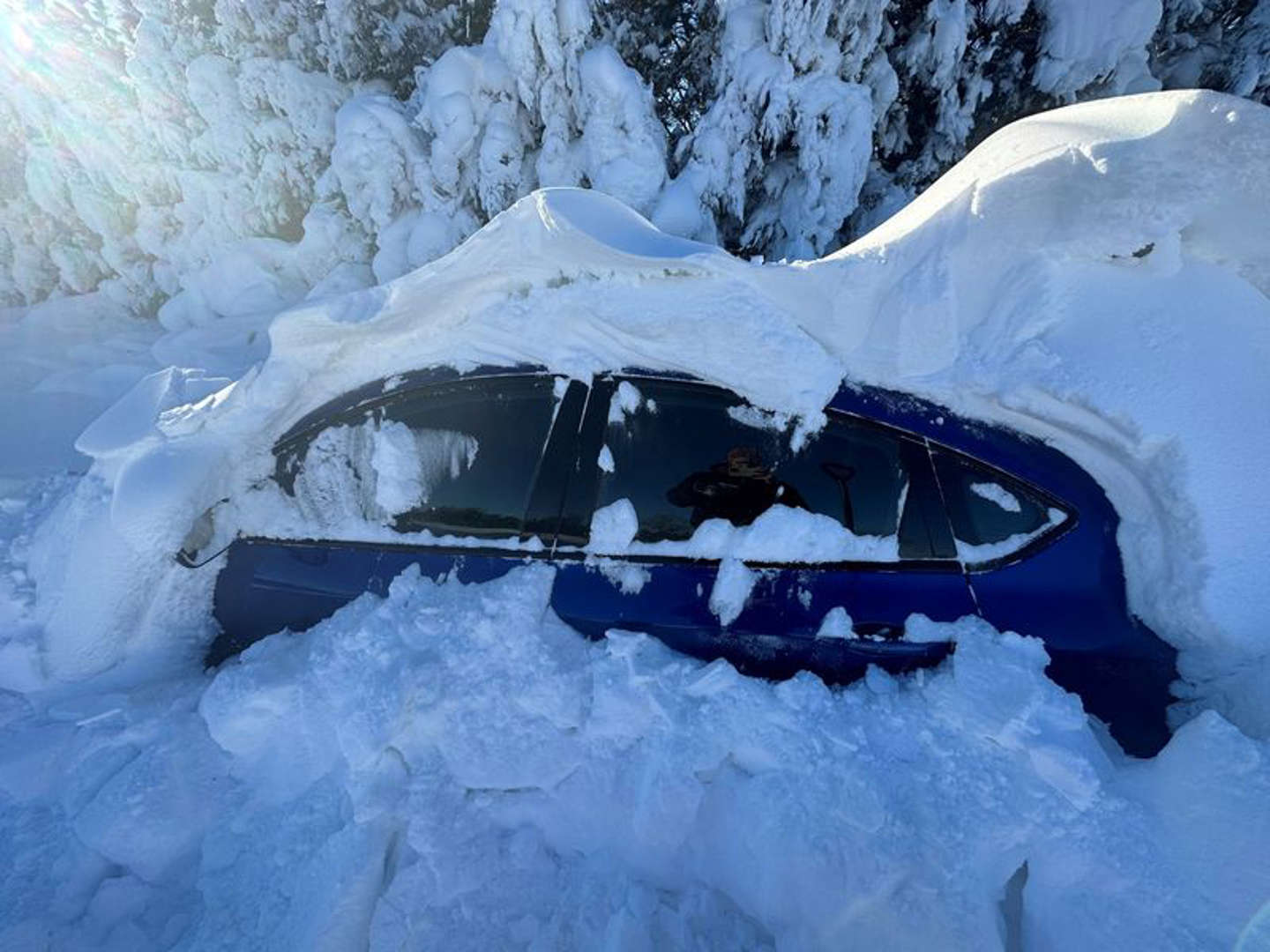
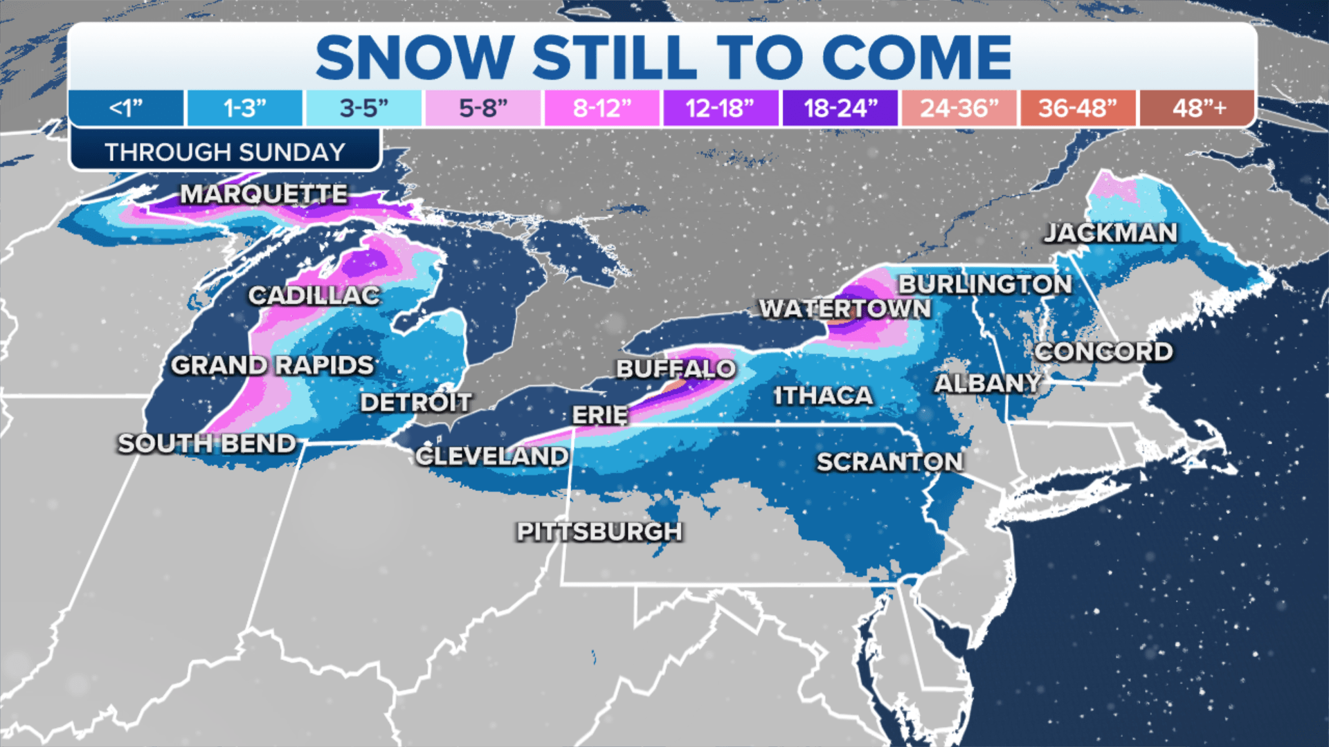
A lack of moisture from the Gulf of Mexico helped keep snow totals on the low side with the heaviest precipitation expected in communities along the Great Lakes. According to the FOX Forecast Center, more than a foot of snow could pile up in the Upper Peninsula of Michigan, western Lower Michigan, far northern Indiana and western and northern New York due to bands of heavy lake-effect snow through the weekend.
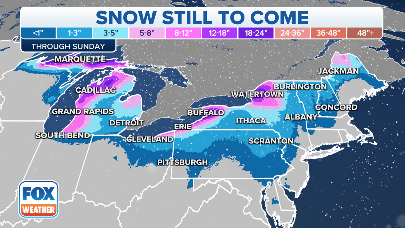
Snow accumulations elsewhere will likely be under 6 inches, except for some locally higher totals from the Adirondacks of New York to the Green Mountains of Vermont, White Mountains of New Hampshire and parts of northern Maine.
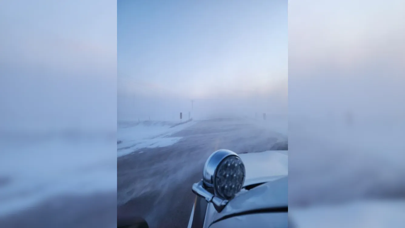
The winter storm reached its peak intensity Friday over the Great Lakes but occasional blizzard conditions will continue to snarl travel from the Upper Midwest eastward to portions of Michigan and western and northern New York, into the weekend.
According to the FOX Forecast Center, the high winds will likely contribute to thousands of additional power outages across the Great Lakes and Northeast, which could turn into a life-threatening situation for those who lose power amid such frigid temperatures.
Additionally, for coastal communities from the Delmarva Peninsula through Maine, onshore winds could continue to lead to significant coastal flooding threat along south-facing coastlines during periods of high tide. The FOX Forecast Center said the flood levels could potentially rank among the 10 highest on record along portions of the Northeast and New England coasts.
Christmas weekend: Feet of snow to bury Great Lakes snowbelts
On Christmas Eve, the winter storm will exit into eastern Canada, but high winds will continue to impact the Upper Midwest, Great Lakes and parts of the Northeast. As those winds blow over the lakes, intense lake-effect snow bands are expected to develop in the Great Lakes snowbelts and dump heavy snowfall in localized areas through at least Christmas Day.
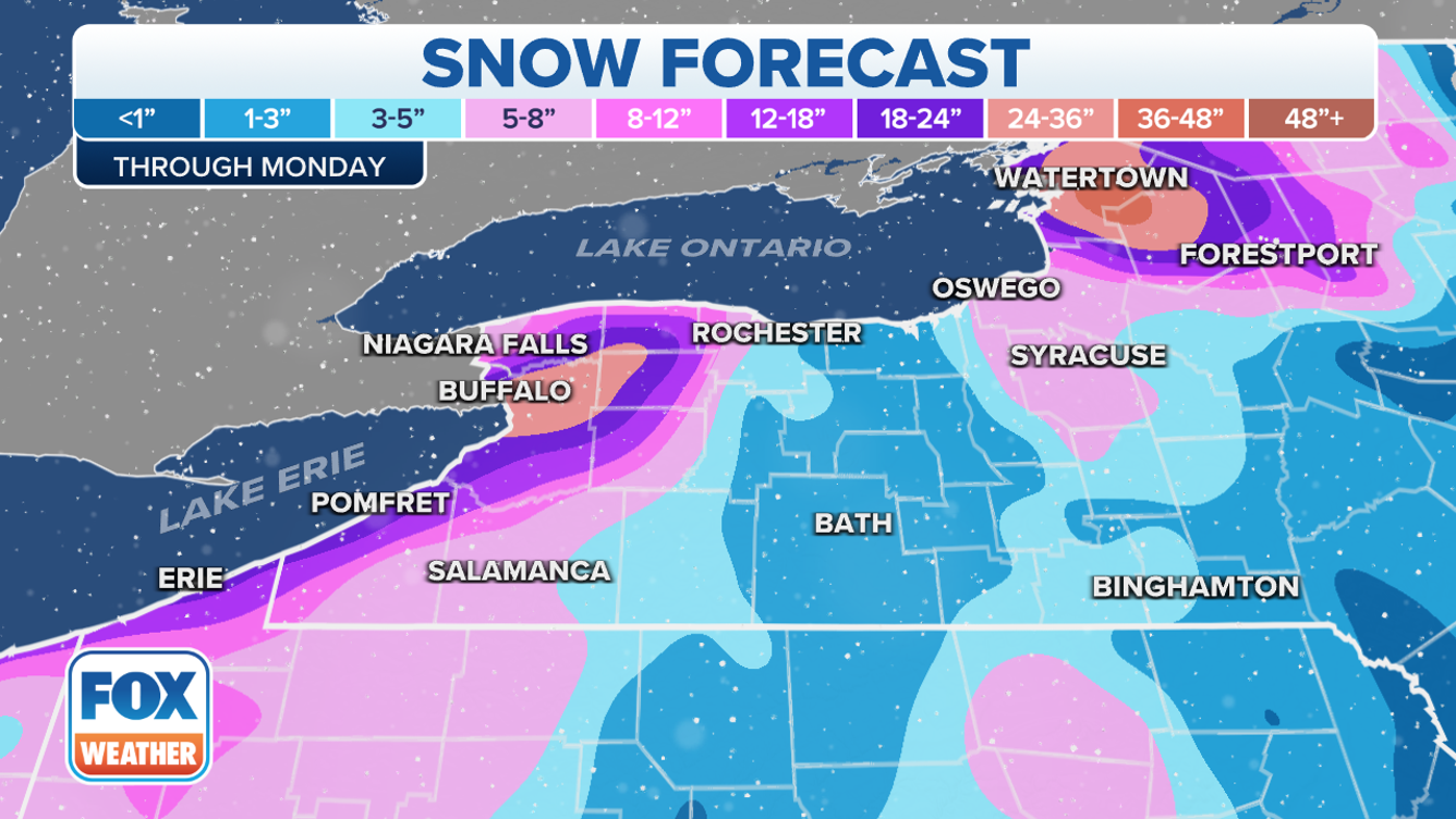
Buffalo, New York, has been placed under a Blizzard Warning due to the combination of heavy lake-effect snow and high winds.
“High confidence continues for expected blizzard conditions downwind of both Lake Erie as well as for Jefferson County off Lake Ontario,” the National Weather Service office in Buffalo wrote in a forecast discussion. “The expectation is that the combination of heavy lake-effect snow and very strong winds will produce blizzard conditions across the Niagara Frontier starting (Friday) afternoon and lasting into Saturday night, with these same blizzard conditions starting in Jefferson County by (Friday) afternoon and lasting into Sunday morning.”
A travel ban is in place for Erie County and the city of Buffalo in western New York. FOX Weather’s Max Gorden reports from along the shores of Lake Erie in Hamburg, NY.
According to the FOX Forecast Center, snowfall amounts through Monday will range from 1 to 4 feet not only across western and northern New York, but also in the Upper Peninsula of Michigan and western Lower Michigan.
The lingering gusty winds will also continue to produce dangerously cold wind chills throughout Christmas weekend, which could seriously threaten anyone who remains without power.
Record-breaking cold, life–threatening wind chills
plunge 150 million Americans into deep freeze
Fox Weather News Source FOX Weather
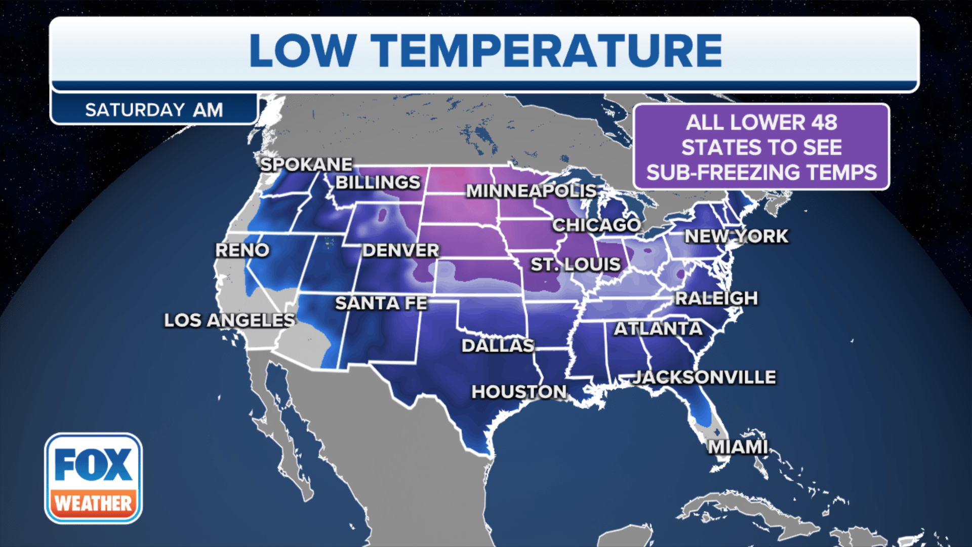
Subfreezing temperatures have reached as far south as the Gulf Coast as millions across the region feel their coldest wintertime temperatures in several years. Dangerously cold temperatures will now spread into the Great Lakes and Northeast for Christmas weekend, freezing areas in the wake of a crippling winter storm.
An arctic front is charging through the Great Plains and bringing in dangerously cold arctic air behind it. Along the front, wild temperature drops as some locations saw their temperaturesplummet by as much 45 degrees in just one hour.
A bitter and potentially deadly blast of arctic air is continuing to charge its way across the U.S., dropping wind chills to as low as between negative 50 and negative 70 degrees across the northern Plains, and 30 below zero in the Midwest.
Rare Hard Freeze Warnings have also been triggered along the Gulf Coast fueling a monster blizzard that will bring that frigid temperature across the Great Lakes and into the Northeast.The dangerously cold arctic air began its week-long journey by surging to the south out of Canada last weekend, dropping low temperatures Monday morning to negative 20 degrees and lower across northern Montana.
Wind Chill Warnings are in effect for most of the northern and central Plains, Midwest, parts of the inland Northwest, South Texas, including Houston, and into Florida.
More than 150 million Americans are under various cold temperature alerts, with the worst of the weather arriving before Christmas.
It’s not only the record-breaking cold temperatures coming with the arctic front, but also a period of snow and strong winds that reached as far south as Oklahoma on Thursday and as far east as New York as of Friday morning.
Winds gusted to more than 30 mph, creating extremely hazardous travel conditions from Kansas to Wisconsin.
South goes into the Deep Freeze
After spending days freezing the Midwest, the bitter blast of cold air will surge south and east Friday. That will send temperatures tumbling from the southern Plains to the Southeast.
Morning low temperatures Friday morning were in the teens and single digits as far south as Oklahoma, Arkansas and Tennessee, according to the FOX Forecast Center, while temperatures remained in the teens from Central Texas to Georgia.
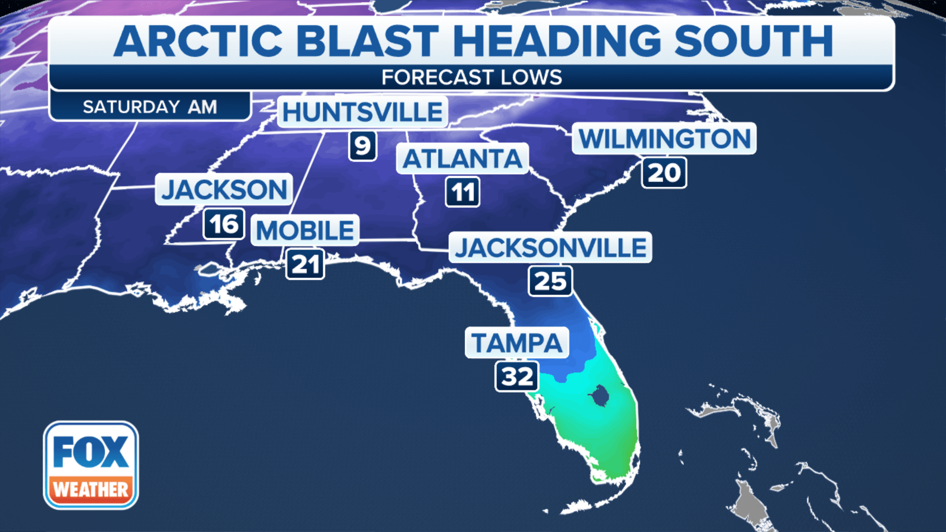
Dallas Fort Worth International Airport dipped to 11 degrees early Friday – one of its coldest December temperatures since 1989. Nashville, Tennessee, bottomed out at negative 1 degree Friday morning, marking the first time the city has dropped below zero since Feb. 5, 1996. Houston dropped to 15 degrees Friday morning and struggle to reach the freezing mark during the day.
“Areas like Oklahoma, Arkansas, northern Texas and northern Louisiana, and the Mississippi Delta – you have to be prepared for the cold as well as potential power outages as the wind gusts will be quite strong along with the potential for a freeze,” said FOX Weather meteorologist Steve Bender. Hard Freeze alerts are now in effect for much of the South – even touching the Gulf Coast shores.
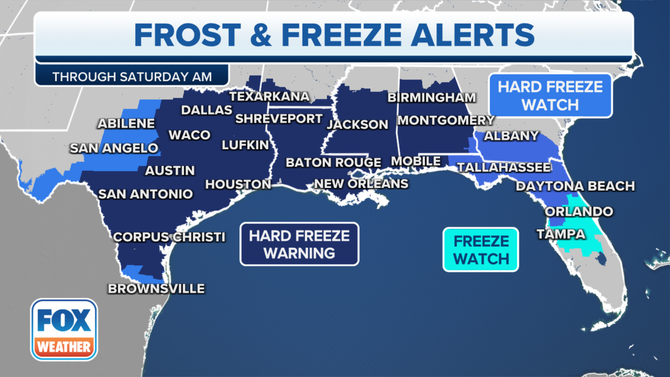
The chill will likely be some of the coldest readings in at least five years for many areas east of the Mississippi River, and Wind Chill Advisories extended into the Gulf Coast. For parts of North Texas and Oklahoma, the Wind Chill alerts are the first issued in the area in 11 years.
Several other locations across the South may not get out of the teens or 20s on Friday, setting records for lowest maximum temperatures. The arctic air will remain entrenched through the weekend – even reaching into Florida on Saturday, where low temperatures will drop to near-freezing as far south as Orlando by Christmas morning.
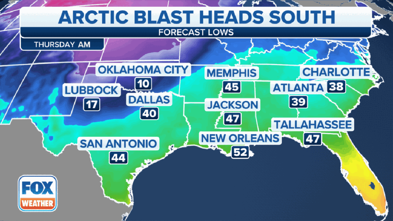
Temperatures could dip into the 20s across central and northern Florida. Even South Florida will be waking up to temperatures in the 40s.
Dangerous chill moves into Great Lakes, parts of Northeast
Meanwhile, heavy snow, fueled by moisture from the Great Lakes, has buried portions of the Midwest with blizzard conditions. The FOX Forecast Center said blizzard conditions have been reported in the Plains and Great Lakes, creating devastating holiday travel impacts. Several airlines are allowing travelers to change flight plans ahead of the storm.
With temperatures expected to drop below zero in the Windy City, slushy snow will freeze overnight, says Robert Ray, FOX Weather correspondent. Northeastern Illinois sees the threat of bursting pipes and power outages amid the Christmas week blizzard.
Bomb cyclone, COVID-19 won’t slow down Santa‘s Christmas deliveries, NORAD says Click Here to Track Santa with the US Military Boys and Girls!
Read how the US Military Tracks Santa’s Christmas deliveries, NORAD says……
Snow, bitter cold, travel nightmares continue Christmas Eve as deadly bomb cyclone enters final chapter
The deaths of more than a dozen people across the country have been blamed on the Christmas week storm that has brought snow, damaging winds and an arctic blast to the eastern half of the U.S.
A major winter storm that killed more than a dozen people, brought blizzard conditions to multiple states and knocked out power to over 1 million customers is still wreaking havoc on Christmas Eve.
As the storm heads into Canada, the lake-effect snow will take over Saturday. Strong winds within the lake bands continue to cause blizzard conditions in western New York and Michigan as Winter Storm and Blizzard warnings are scattered across the region.
Subfreezing temperatures have reached as far south as the Gulf Coast as Freeze Warnings blanket the southern part of the country. Some locations as far south as central Florida are even feeling their coldest wintertime temperatures in several years.
Dangerously cold temperatures will now spread into the Great Lakes and Northeast for Christmas weekend, freezing areas in the wake of a crippling winter storm. Saturday and Sunday will be the coldest days along the Eastern Seaboard down to the Southeast.
Temperatures will begin to warm gradually starting Monday with most of the country returning to above-average temperatures by the middle of the week.
It isn’t just this arctic blast causing a holiday disaster. Multiple feet of snow have jeopardized Christmas travel plans for the once 150 million Americans under some winter weather alert.
The Christmas week storm also proved deadly, with as many as 17 deaths reported due to the combination of dangerous driving conditions and frigid temperatures.
At least four people were killed after a massive pileup in Ohio on Friday. It happened along eastbound Interstate 80 between Route 53 and State Route 4 in Sandusky County. At least 46 cars were involved.
intense pressure, which became a bomb cyclone early Friday, will continue to produce strong winds and lake-effect snow from the Great Lakes to the Northeast, weakening by Christmas evening.
The strong winds and snow will continue to produce blizzard conditions with visibility as low as a few hundred feet.
The FOX Forecast Center said snowfall rates would sometimes exceed 2 inches an hour. More than 2-4 feet of snow is likely across much of Michigan and western New York. It will not be surprising if some locations near Buffalo and Watertown, New York, pick up 5-6 feet.
Wind gusts, which have been as high as 75 mph in Ohio and New York, will continue to be gusty as high as 40-plus mph all across the Midwest and Northeast on Saturday. Gusts will continue in the 50-70 mph range along and near the Great Lakes.
These winds atop existing snow cover will produce ground blizzards. The gusty winds will also continue to result in damage and power outages.
ind gusts that were tropical storm-force and even hurricane-force in some areas knocked power out to more than 1.4 million customers from Texas to Maine this week, with a separate ice storm causing outages in the Pacific Northwest.
The strong wind will produce an increased danger if power outages occur. In addition, the cold’s danger will increase if any power outages occur due to the widespread gusty winds around the winter storm system. The lake-effect snow will finally begin to wind down on Christmas evening, and only a few lingering snow showers will remain Monday. cited